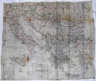
Map [Escape Map]
Object detail
Accession number
2004.42
Description
Silk, escape map - double-sided. One side depicts Albania, Bulgaria, Greece, Turkey. There is an inset map of Crete and Karpathos in the Sea of Crete. Roads are marked in red, international boundaries in green, all other features are depicted in black. The corners are marked in red or black, S2/S3 or S2. When oriented North, there is a legend in the lower left corner of the map. The scale of the map is 1:1,750,000. The map is divided into a grid with number ranges running vertically (35-42) and horizontally (19-30). On the reverse is a map of Switzerland, Italy, Austria, Hungary, Yugoslavia, Romania, Bulgaria, Greece, Crete and Western Turkey. Roads are indicated in red, international boundaries in green and other features in black. In the corners S3 is marked in black. Along the bottom of the map, when oriented North, there is a chart of conversions for kilometres into English miles. There is also a legend. The scale of this map is 1:3,000,000. The map is divided into a grid with a vertical scale (36-46) and horizontal scale (10-30). The scales on both sides indicate longitude and latitude. Both maps are on a cream-coloured background.
Media/Materials
Collection
Credit Line
Map [Escape Map], 2004.42. The Museum of Transport and Technology (MOTAT).


Public comments
Be the first to comment on this object record.