![[Lakunai Airfield (New Britain) - navigation map]](https://collection.motat.nz/records/images/xlarge/4669/c61658116b220859da9d756e99b22575041f9eb5.jpg "[Lakunai Airfield (New Britain) - navigation map]")
[Lakunai Airfield (New Britain) - navigation map]
Maker and role
United States Hydrographic Office, Maker
Production date
1940s
See full details
Object detail
Accession number
2002.161
Description
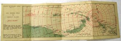
Aerial navigation map no. 16 Q. showing Lakunai Airfield and surrounding area.
Marks
"N.A.C.I. COSMOPAC No.16Q; 1st AVN.ENGR.BN. J241P52 1.1.44." Printed
Media/Materials
Physical description
1 leaf ; 20 x 20 cm
Credit Line
United States Hydrographic Office. 1940s. [Lakunai Airfield (New Britain) - navigation map], 2002.161. Walsh Memorial Library, The Museum of Transport and Technology (MOTAT).
![AAF cloth map - Southwest Pacific area [No. 16 Owen Stanley -- No. 17 New Britain]; Army Map Service, US Army; 1944](https://collection.motat.nz/records/images/medium/4646/471ded036be82141322a5fc06eadf53e1d365e70.jpg)
![New Britain and New Ireland [map]; United States Hydrographic Office; [1940s]](https://collection.motat.nz/records/images/medium/4658/bc53aef99894204959b584dfb63a6d656e841cb5.jpg)
![[Lakunai Airfield (New Britain) - navigation map]; United States Hydrographic Office; 1940s](https://collection.motat.nz/records/images/medium/4669/c61658116b220859da9d756e99b22575041f9eb5.jpg)
Public comments
Be the first to comment on this object record.